Monday, March 24, 2008

Big Sur Surprise


It was still dark when we left Ragged Point but early morning sunlight brightened the horizon. Four members of the San Luis Obispo Bicycle Club embarked on a bike tour to Big Sur on Highway 1 to get a taste of the Tour of California’s Stage 4, from Seaside to San Luis Obispo.
Reverse Alpenglow painted the western clouds in shades of pink and orange as dawn broke. No cars passed; we owned the road in the early morning.
The air temperature along the coast was warmer than it had been when I drove through Cambria. Occasional breaths of cooler air caressed us as we passed tiny canyon inlets. The rocky hillside was littered with clumps of pampas grass.
We had a beautiful clear morning with a three-quarter moon hanging halfway down the sky. A gray fog bank sat on the horizon. White and purple morning glories polka-dotted the rocky hillside and flowering yucca plants lit up the slopes like candles. A thousand feet below, long-plumed mare’s tails streamed off the crests of breaking waves.
The only sounds were the hum of the tires, the whir of the chain, and early morning birdsong. We shared the highway with roadrunners and cottontail rabbits. The bunnies darted in erratic zigzag patterns and the roadrunners took flight as we approached.
Chunks of sedimentary rock on the pavement reminded me that Highway 1 is built across the foot of a mountain range that is constantly trying to return to the sea.
California’s legislature designated Highway 1 as an official state bicycle route in 1990, based partly on its being a "challenging route that passes some of the nation’s most beautiful scenery." It is beautiful and it is challenging–we climbed more than 8,000 feet during our seven-hour journey, pedaling past redwood forests and Monterey pines, agate-studded beaches, sea rocks painted white with guano, barking sea lions, and hawks that hovered above foam-stitched breakers peering deep into the water looking for breakfast.
When we descended to sea level at Willow Creek, the iodine-and-salt smell of the ocean–fish and floating kelp–washed over us. I heard sea lions barking and saw a pair of them on an offshore rock , facing each other in pinniped conversation.
From the crossing at Limekiln Creek, Cone Peak rises three miles inland. It is a mile high and represents the steepest elevation change on the west coast of America.
We climbed the last hill into Lucia past a high rock slope on the right that is covered with black chain link netting designed to confine falling rocks and protect bicyclists.
We chatted briefly at the store with Persay Bryant, who described himself as a thespian and expressed his philosophy of life by saying, "I am content in whatever state I’m in." At that moment he was in the state of California in a state of sobriety.
North of Lucia, rolling hills provided intermittent views of the coastline. At Julia Pfeiffer Burns State Park, McWay Creek dropped 60 feet over a rock ledge, the only waterfall in California that descends directly into the ocean.
As the morning wore on, traffic increased. Shoulder width on Highway 1 varies from several feet to a few inches. Whenever we heard a car coming, we pulled as far to the right as we could and made room to share the road.
Only one motorist talked to us, a passenger in a dirty brown Volvo who shouted something as he whizzed by. I didn’t hear what he said but it sounded as if he was complimenting our riding technique or our colorful jerseys or our magnificently muscled legs.
We climbed to a summit at Nepenthe, then a long descent past Pfeiffer Big Sur State Park into Big Sur and Bob Robinson’s Fernwood Resort. Bob had a big barbecue/smoker going out front and was cooking chicken, sausage, pork tenderloin, roast beef and ham plus baked potatoes, mushrooms and corn–all we could eat for $9.99. I don’t think we put him out of business but we tried.
The wind picked up on the way back and though it was mostly coming from behind us, erratic side gusts added excitement to the final roller coaster descent into Ragged Point.
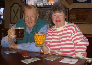
At the end of the ride, we rested and had a beer at the Ragged Point restaurant and watched the end of a wedding ceremony in the garden below. Pat suggested that we ask them to start over so we could see the beginning, but instead we sat and watched the happy couple toast their first toast and dance their first dance.

Wednesday, March 19, 2008

Adelaida


North county autumn weather can be delightful as summer heat begins to moderate and leaves turn bright fall colors. The dozen or so wineries in the area are starting to harvest this year’s vintage. Dry summer weather produces concentrated wine grapes. West of Paso Robles you can find good wine and good bike riding.
Three main roads cut across the area. They are Peachy Canyon, Adelaida and Nacimiento Lake/Chimney Rock. Each has its charms and challenges. They are connected at their western ends by Vineyard Drive, which ambles northward from Highway 46.
The roads are very similar from a cyclist’s standpoint–like life, they have their ups and downs. You change gears often as you ride across the hills. The pavement is narrow and winding but you don’t see much car traffic. Most of the time it’s just you and your bike and the scenery.
Oak trees hanging with Spanish moss shade the western ends of these roads. Deer gangs lurk, looking for things to nibble on. Wild turkeys squabble and gobble their way across the fields. Grapevines fly ribbons of shiny tape or huddle beneath netting to keep birds away from the fruit.
The northernmost road leaves Paso Robles heading for the lake. Nacimiento Lake Drive has a wide shoulder and lots of fast traffic. Its scenic value is limited. Eight miles out of town, take the left fork onto Chimney Rock Road. What you lose in shoulder width, you gain in open country charm. After six miles of rolling hills and open vistas, Chimney Rock meets Vineyard Drive.
Turn south on Vineyard to ride 2 ½ miles to Adelaida Road. Adelaida climbs back toward Paso Robles for four miles to a high point in its center. From there, the road descends five miles to connect with Lake Nacimiento Drive two miles west of Paso Robles.
To get to Peachy Canyon Road, ride west on 6th Street. Turn right on Olive, left on Pacific. Pacific becomes Peachy Canyon. In short order, you’re out of town and climbing. This is a delightful road full of twists and turns, climbs and descents. At its western end, you have a choice of taking Las Tablas/Willow Creek Road south or connecting again with Vineyard Drive. Both will lead you to Highway 46 if that’s what you want.
Other roads cris-cross the area. Niderer is a mile of shady road that ends at Dunning Vineyards. Oakdale and Jack Creek both parallel Highway 46 and provide a pleasant alternative to riding alongside high-speed traffic. Klau Mine Road leads you down a shady canyon for a couple of miles before turning to dirt.
For something completely different, stop by Willow Creek Olive Ranch–on Vineyard Drive between Peachy Canyon and Adelaida Roads, a half mile north of Norman Vineyards–and explore the world of award-winning olive oils. The tasting room is open Fri-Sun from 11-5, other times by appointment. Find out what makes an olive oil extra-virgin and what happens when it is not.
One of the least-traveled roads in the Adelaida area is Chimney Rock west of Vineyard. Pedal eight miles past Justin Vineyards, crossing two arms of Lake Nacimiento, to the end of the county road. You will see signs that tell you the road does not go to the ocean and it does not go to the lake. The signs are correct. At the end of the public road, additional signs at a cattle guard tell you that you are about to enter private property. Turn around and pedal back.
As always when you ride in rural areas, be courteous to car drivers and give them plenty of room. We can all share the roads safely with a little effort and respect for others.
INFORMATION BOX: To explore the area’s wineries, check out http://www.faroutwineries.com;/ Willow Creek Olive Ranch’s website is www.willowcreekoliveranch.com.

Thursday, February 14, 2008

Bitterwater Road


San Luis Obispo Bicycle Club founder, Larry Souza (the original SLOB), initiated the club’s annual Wildflower Century in 1971. This ride follows most of that early route, but in reverse. It is seventy miles and takes about five hours. No water is available during the last fifty miles nor are there any other amenities on the route. This ride is for serious lovers of solitude and self-reliance.
Park at the intersection of Highway 58 and Shell Creek Road nineteen miles east of Santa Margarita.
Shell Creek/Truesdale/San Juan Roads - Sixteen and one-half miles through the Avenales Wildlife Area following Shell Creek northward from Highway 58 to Highway 46. At ten miles, turn right on Truesdale Road for one-half mile. Then turn left on Shandon/San Juan Road. Turn left on Toby Way, then right on Centre Street. You pass by the outskirts of Shandon before connecting with Highway 46.
The good: Long, flat, smooth road with little traffic. Cows and horses graze alongside irrigated meadows and fruitful vineyards. Friendly drivers wave back at friendly bicyclists.
The bad: The road has no shoulder but traffic is light.
State Highway 46 - Four and one-half miles to Bitterwater Road. Caltrans maintains a roadside rest area one mile east of Shandon with rest rooms and drinking fountains. This is the last fresh water you will see on the ride.
The good: Riding shoulders wide enough to accommodate bicycles. A rumble strip separates the shoulder from the main traveled way.
The bad: Debris on the shoulder. Fast traffic.
Bitterwater Road - Thirty-two miles following the San Andreas Fault. The first seven miles climb 1000 feet up Palo Prieto Canyon. Two miles beyond the summit, you will see the Greensberg General Store. It has been closed a long time. The road forks here. Go right and continue riding through Choice Valley. Along this stretch you will dip into and out of a corner of Kern County.
At the halfway point, you come to an intersection with Bitterwater Valley Road. It goes to the left and connects to Highway 46 near Blackwell’s Corner. You want to continue straight on Bitterwater Road.
The next five miles are rolling climbs and dips. At Las Yeguas Ranch you begin a long, satisfying downhill ride to Highway 58 in the California Valley. Keep an eye open for antelopes.
The good: Solitude if you love it. Lots of open ranch land. Cattle grazing in open meadows. Good road surface for the most part with little traffic.
The bad: Solitude if it makes you uncomfortable. No food, no water, no amenities. Just you and your bicycle and your thoughts.
Highway 58 - Eighteen miles of rolling hills with a generally downward gradient to the intersection with Shell Creek Road. You cross San Juan Creek and pass La Panza Ranch at Pozo Road. Five miles east of Shell Creek Road, a dirt road turns off to Navajo Camp, La Panza Camp and Friis Camp.
The good: "Carrisa Plains 4H Welcomes You." Beautiful deep ravines and strange rock formations line the highway. Green, rolling hills splashed with yellow and orange and purple flowers provide picturesque backdrops for grazing cattle. You have a couple of little climbs but for the most part this is fast riding with not much traffic. Friendly drivers give you lots of room.
The bad: Grouchy drivers tend to crowd bicyclists. The shoulder is narrow to non-existent so court friendliness.
Shell Creek Road - Here is where you parked. The ride is over. If you want to recreate the original WildFlower Century, begin your ride in Creston. Take Highway 229 to Highway 58. Ride east to Shell Creek Road. Follow the route described above in reverse back to the junction of Shell Creek Road and Highway 58. Turn right on Highway 58,then right on La Panza Road. Turn left on Highway 41, then immediately left again on Highway 229 to ride into Creston.
San Luis Obispo Bicycle Club’s Wildflower Ride takes place in April. Specific routing varies from year to year. The club’s website is http://www.slobc.org/rides/Wildflower.html.

Sunday, February 3, 2008

Adelaida


North county autumn weather can be delightful as summer heat begins to moderate and leaves turn bright fall colors. The dozen or so wineries in the area are starting to harvest this year’s vintage. Dry summer weather produces concentrated wine grapes. West of Paso Robles you can find good wine and good bike riding.
Three main roads cut across the area. They are Peachy Canyon, Adelaida and Nacimiento Lake/Chimney Rock. Each has its charms and challenges. They are connected at their western ends by Vineyard Drive, which ambles northward from Highway 46.
The roads are very similar from a cyclist’s standpoint–like life, they have their ups and downs. You change gears often as you ride across the hills. The pavement is narrow and winding but you don’t see much car traffic. Most of the time it’s just you and your bike and the scenery.
Oak trees hanging with Spanish moss shade the western ends of these roads. Deer gangs lurk, looking for things to nibble on. Wild turkeys squabble and gobble their way across the fields. Grapevines fly ribbons of shiny tape or huddle beneath netting to keep birds away from the fruit.
The northernmost road leaves Paso Robles heading for the lake. Nacimiento Lake Drive has a wide shoulder and lots of fast traffic. Its scenic value is limited. Eight miles out of town, take the left fork onto Chimney Rock Road. What you lose in shoulder width, you gain in open country charm. After six miles of rolling hills and open vistas, Chimney Rock meets Vineyard Drive.
Turn south on Vineyard to ride 2 ½ miles to Adelaida Road. Adelaida climbs back toward Paso Robles for four miles to a high point in its center. From there, the road descends five miles to connect with Lake Nacimiento Drive two miles west of Paso Robles.
To get to Peachy Canyon Road, ride west on 6th Street. Turn right on Olive, left on Pacific. Pacific becomes Peachy Canyon. In short order, you’re out of town and climbing. This is a delightful road full of twists and turns, climbs and descents. At its western end, you have a choice of taking Las Tablas/Willow Creek Road south or connecting again with Vineyard Drive. Both will lead you to Highway 46 if that’s what you want.
Other roads cris-cross the area. Niderer is a mile of shady road that ends at Dunning Vineyards. Oakdale and Jack Creek both parallel Highway 46 and provide a pleasant alternative to riding alongside high-speed traffic. Klau Mine Road leads you down a shady canyon for a couple of miles before turning to dirt.
For something completely different, stop by Willow Creek Olive Ranch–on Vineyard Drive between Peachy Canyon and Adelaida Roads, a half mile north of Norman Vineyards–and explore the world of award-winning olive oils. The tasting room is open Fri-Sun from 11-5, other times by appointment. Find out what makes an olive oil extra-virgin and what happens when it is not.
One of the least-traveled roads in the Adelaida area is Chimney Rock west of Vineyard. Pedal eight miles past Justin Vineyards, crossing two arms of Lake Nacimiento, to the end of the county road. You will see signs that tell you the road does not go to the ocean and it does not go to the lake. The signs are correct. At the end of the public road, additional signs at a cattle guard tell you that you are about to enter private property. Turn around and pedal back.
As always when you ride in rural areas, be courteous to car drivers and give them plenty of room. We can all share the roads safely with a little effort and respect for others.

Saturday, February 2, 2008

Amgen Tour of California 2008


San Luis Obispo will, for the third time, host Stage 4 of the Amgen Tour of California professional bicycle race, on February 21st, 2008. Sixteen pro teams, more than a hundred cyclists, will speed down Chorro Street and make the tight turn onto Monterey for a dash to the finish line as they complete a 130-mile stage that begins that morning in Seaside.
That will be the fifth consecutive day of racing for the third annual Tour of California, an eight-day event ranging across the state from Santa Rosa to Long Beach.
Local cycling enthusiasts will have plenty of opportunities to participate in the event, either as a cyclist or as a volunteer.
Bike riders can get close to the racers and ride the course with John Flaherty of Central Coast Outdoors. John offers two different day-trips based out of San Luis Obispo to watch the race and to ride portions of the routes.
On Thursday, participants will ride from Carmel to a viewpoint near Bixby Bridge and watch the racers as they climb a long hill that is one of the King of the Mountains qualifiers. After the racers pass by, John’s group will ride some of the best sections of Highway One back to San Luis Obispo and enjoy a gourmet picnic lunch along the way.
John says that on Friday, "We'll depart San Luis Obispo in the morning so we'll have time to rub elbows with the racers as they get ready to ride. Once the leaders finish in the early afternoon, we'll have an opportunity to ride the 14.5 mile course ourselves (maybe twice or with some longer options added in for fun) before heading back to San Luis Obispo."
You can sign up for one or both tours or get more details by calling 888-873-5610.
Volunteers who want to serve as course marshals, survey takers, conduct registration or provide security will have an opportunity to both actively participate in the event and to support the race. You can sign up at Amgen’s website at http://www.amgentourofcalifornia.com/Tour/volunteer.html or call City Parks, 781-7300, or contact Richard Ogden at rogden@slocity.org.
Mayor Dave Romero welcomes the race–"The City of San Luis Obispo is a bicycle-oriented community; therefore, the Amgen Tour of California is a perfect fit for us. The City is delighted to host the Amgen Tour of California once again."
Two local riders will race–Lucas Euser, who graduated from Cal Poly in December, will be back for his second year in the Tour riding for Team Slipstream Powered By Chipotle (formerly known as TIAA-CREF). Ken Hanson, another Cal Poly graduate and former head of the Wheelmen, will race for BMC.
The city will again set up a big screen TV at the corner of Chorro and Monterey, the infamous last turn before the sprint finish to Osos Street. Organizers expect the race to end about 3:00 pm on Thursday.
San Luis Obispo Bicycle Club and the Bike Coalition are taking an active role in supporting the event, working with the Chamber of Commerce and the county’s other primary cycling organizations–Cal Poly Wheelmen, SLO Nexus and Central Coast Concerned Mountain Bikers. Bike Valet will be set up on Morro Street to provide free, secure parking for anyone who rides a bicycle downtown on race day.
Everyone is invited to come downtown for a community festival on the 22nd and enjoy exhibits featuring health & fitness products, cycling gear, bike safety demonstrations, entertainment, food and activities for the whole family–then stay afterward for Farmers Market.

Friday, January 25, 2008

Central Coast Double


Eighteen bicycle riders labored up the steep hill. A thousand feet below them, Pacific Ocean waves crashed onto the beach. A thousand feet above them, the road disappeared into pine trees. Sweat dripped off their faces. Flies swarmed around their heads. Some riders ran out of water. A car approached. The driver stopped to refill empty water bottles. He encouraged the riders, "Only five more miles to the top."
This was 1995, the inaugural Central Coast Double (CCD), a 210-mile bicycle ride that starts in Paso Robles, goes through Cambria, up Highway One and over Nacimiento-Ferguson Road to Fort Hunter Liggett. After a lunch break, the route continues north almost to King City, then back to Lake San Antonio, Bradley, San Miguel and Paso Robles. CCD is the dream-child of local ultra-cyclist Brian Stark.
Mudslides, floods, war and destruction--Brian never knows what he will have to deal with. Covering so much territory almost guarantees that some act of nature or man will challenge his ability each year to provide a continuous route.
One year Caltrans closed Highway One north of Ragged Point. Brian had to send the riders west through Hunter Liggett over Nacimiento-Ferguson Road to the coast. Then they turned around and rode back. The hair-raising, brake-gripping seven-mile, 2500-foot descent from the summit of the Santa Lucia mountains to the sea was followed immediately by a lung-busting, thigh-burning, sweat-dripping climb back up.
Another time, the Estrella River flooded River Road north of Paso Robles. Brian had to reroute riders ten miles east to a bridge crossing to get them from San Miguel back to Paso Robles.
Since 2001, heightened security measures have resulted in the Army restricting civilian travel through Fort Hunter Liggett. Gate guards require each of the approximately 150 CCD cyclists to show picture ID to get to the lunch stop.
Brian starts the riders at 5:40 a.m. from Paso Robles City Park. The course closes at midnight. Typically, eighty per cent of the starters are able to complete the ride within the time limit. Although this is not a race, Brian does record finish times. Fastest completion so far is 10:53 by three riders in 1999.
For those who want an easier route, Brian has added a shortened version of the ride–170 miles and 10,500 feet of climbing–that he has named Central Coast Challenge. Imagine climbing stairs from Furnace Creek to Whitney Portal. That’s Brian’s easy route.
Forty volunteers help put the event on. San Luis Obispo Bicycle Club members and other volunteers help on the course and provide equipment. Keith Schmidt, owner of K-Man Cyclery, acts as headquarters and sponsors the ride, along with Hammer Gel Nutrition.
Paso Robles Radio Club HAM operators provide communication around the two-county course, using high frequency radios to transmit over the hills. It is important that everyone be accounted for at every stage of the event since much of the riding takes place in isolated areas.
Larry Sarver, web administrator of centralcoastdouble.com, provides a sophisticated website and 3D graphics as well as T-shirt and patch design.
One of the attractions of CCD is the food. Frank Milazzo of Santa Barbara prepares a gourmet after-ride dinner. Out on the course, volunteers serve refreshments at six food stops and a full lunch in the shaded area behind De Anza Gym on Hunter-Liggett. Brian sets up additional water stops in the Interlake area where hot afternoons suck the moisture out of cyclists.
This is a tough ride and it has a time limit. The course closes at midnight and riders must clear the Bradley food stop, Mile 179, no later than 9:45 p.m. Those who can’t finish in time get a ride to the finish line. No one gets left behind.
INFORMATION BOX: May 10th, 2008, Brian will celebrate the fourteenth annual presentation of the Central Coast Double. Check the website at http://www.centralcoastdouble.com for additional information or call K-Man Cyclery at 237-2453. If you want to volunteer to help on the course, call Brian at 239-4397 or email bms_cycling@centralcoastdouble.com. Volunteers receive free T-shirts, patches and meals.

Tuesday, January 22, 2008

You Can Do This


You saw the ad. Two U.S. Postal Service riders are sitting on a couch and a third rider is pulling them up this hill on his bicycle. And he’s thinking about Clif Bars. You know two of the guys, you’ve seen their names in VeloNews. But the guy on the bike, Kenny Labbé, with the accent mark on his last name, who’s that guy?
He’s a worker. He’s like you and me. He works for the post office, delivering the mail through snow and sleet and all that other stuff, walking the rounds in Mount Prospect, Illinois. He’s something else too. During the spring and summer for three years he raced on Thom Weisel’s U.S. Postal Service team, pulling guys like Robbie Ventura and David Zabriskie up through the pack so that when the bell rang for the last lap, they were in position to win and Kenny could drift off to the side and heave his guts up and smile because he did his job–he delivered the mail for the Posties.
How did that happen?
Kenny’s just like you and me, except for maybe a couple of things. He’s blessed with a not-too-bad ability to race bicycles and he has this unquenchable, unstoppable, unkillable determination to race on the best-by-God American cycling team that this country has ever seen.
Kenny had some talent, sure, Northbrook Velodrome Rider of the Year for four years, a couple of respectable finishes at Downer’s Grove. But he wasn’t elite. He wasn’t the best racer in the country, or even in Illinois. He’s no Freddy Gonzales or Levi Leipheimer. So how the heck did he get on the Posties?
If you have to ask, you don’t know Kenny. He’s this guy who had a dream. We all have dreams. We all wish we could do this, or if we had time we could do that. Kenny dreamed that the U.S. Postal Service Pro Cycling Team included a U.S. Postal Service letter carrier, and that it was him. Then he made his dream come true.
One other thing about Kenny–he’s a shameless self-promoter. He has no false humility and if he needs to impress you with an exploit to get your attention, he matter-of-factly lays it out there for you to absorb.
When he worked up his résumé for Mark Gorski, he saw a big hole in it. Northbrook Velodrome Rider of the Year, 21st place at Downer’s Grove. Not enough. Gorski, after all, has an Olympic gold medal and he’s general manager and part owner of the Postal Service team. If you want him to keep reading, you’d better have some sort of national title.
Kenny enlisted his dad to help him train and then set a USCF 12-hour cycling record of 252.5 miles. (Then the USCF retired that category, leaving Kenny Labbé’s name on it forever. Sometimes you’re golden.)
Kenny flew to L.A. to meet Gorski. Gorski listened to him and said, "I’ll give you a call." Kenny waited for what he thought was long enough, then he invited himself to the Postal Team’s training camp in San Luis Obispo.
Gorski said, "Hang around, but keep a low profile." Kenny hung out with the team. He hung on to the end of the pack on their six-hour training rides. Sometimes he hung on to the back of Johan’s car. But he never fell off the back. And he got better. When you ride with the best, some of it rubs off.
Kenny raced a few times with the domestic team in 2000, pulling his teammates through the peloton or going off the front to control the pace while they set themselves up for the finish. But he kept his day job.
The following spring, Gorski invited him to training camp on the Costa del Sol, in the south of Spain. (Hey boss, can I have a few weeks off to ride with Lance in Europe? The Postmaster General says it’s okay.) By now he was holding his own with the big guys.
He raced in 2001 with the domestic team in its U.S. races–Redlands, Sea Otter, Downer’s Grove. At the San Francisco Grand Prix he led out George Hincapie. Can you say "excited?"
What do you do to top that? Maybe a better questions is, "Do you have to top that?" Go to the website http://www.lancearmstrong.com/lance/online2.nsf/html/. Click on "Photo Galleries." There he is, your home town letter carrier, Kenny Labbé, all dressed up in blue and white, photo by Graham Watson.
The Postal Service made a poster of him and put it up in all the post offices. They put on a big dinner for the postal racing team and seated Kenny next to the Postmaster General. Maybe they’ll put his picture on a stamp.
So who is this guy, really? He’s you and he’s me, only maybe he has a little more talent and certainly the ability to sell himself and, most important, all the determination in the world. He had a vision and he made it come true.